
Weird Scenes along the Gold Road - Arizona
8/7/2022

There’s a stretch of Historic U.S. Route 66 in Arizona that from 1926 to 1952 was aligned directly through the Black Mountains between Oatman and Cool Springs. Also known as the Oatman Highway, or Mojave County Route 10, there are like 7 zillion hair-pin curves along that 8-mile-stretch that also includes the awesome Sitgreaves Pass (note: my dates and numbers may be a bit off, as Route 66 has been realigned so many times it’s hard to keep track). Most of this section of Route 66 is narrow, two-lane blacktop with infrequent turnouts. It’s kinda scary along some portions and in the “old days” some drivers reportedly paid professionals to drive them through this section. Silly scaredy-cats.
I was in the area over a short weekend road trip, mainly to visit Oatman and a couple spots along the Gold Road (another moniker for this cool stretch of road, most likely bestowed because of the rich Gold Road Mine, which is still in operation today). Yes, it was well over 100°, but that kept things interesting and the photo opportunities outside the car a little shorter than normal for me. I’ll have to re-explore in a cooler season than mid-summer. But the trip was a success, as I found the main point of interest I was looking for, along with a couple of other nice things as well. Here we go, buckle up….
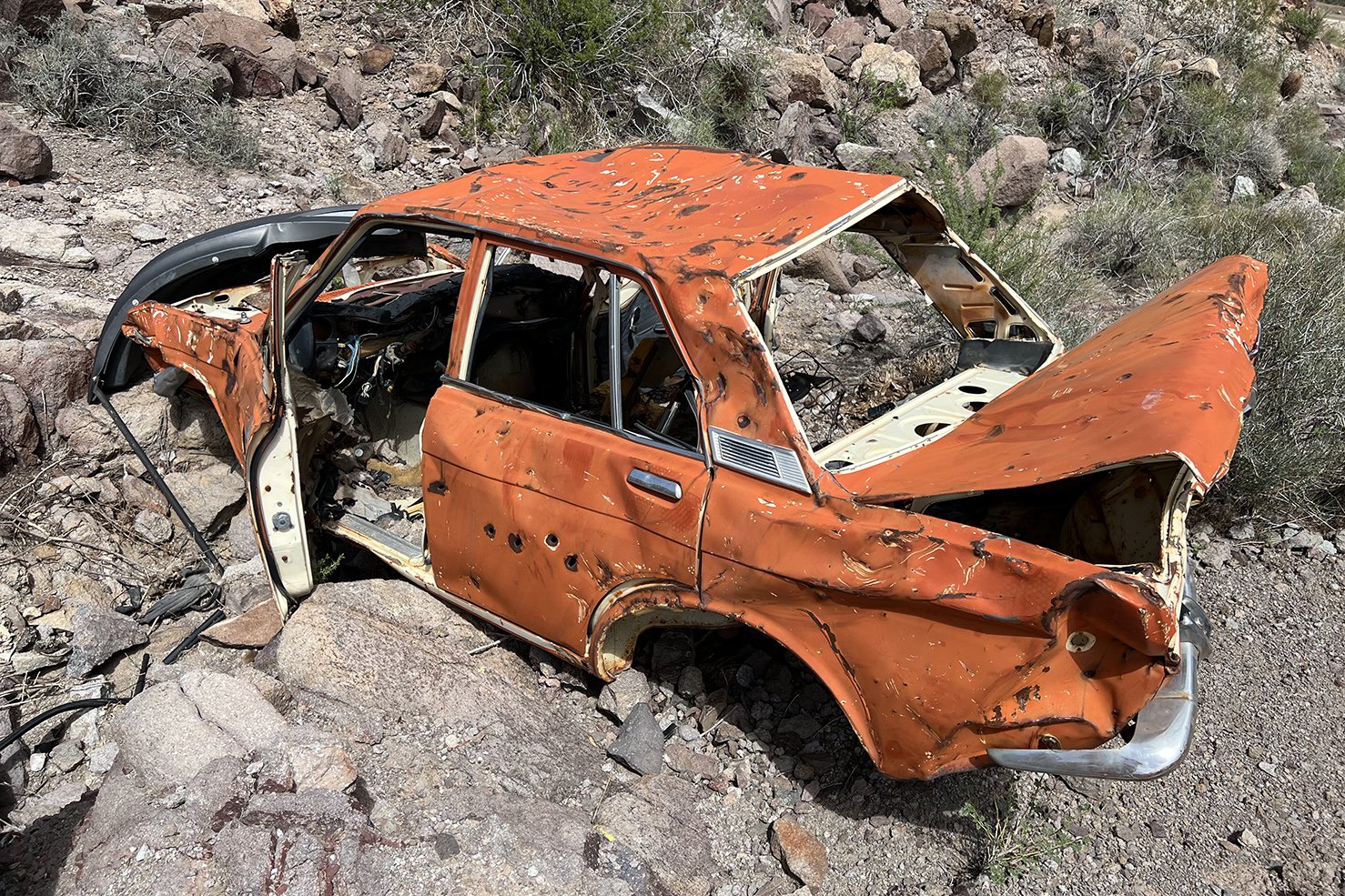
As I was driving along, just before a hairpin turn, and directly under another about 200 feet above, I spotted a flash of orange (the picture at the beginning of this post). It took a while to find a safe place to turn around, return and then park near that spot of orange. Climbing up a very sketchy slope, I got to the remains of this beauty. Hopefully the bullet holes weren’t what caused the crash.

So what to do when driving along, and spotting what appears to be a flight of stairs leading up into the rocky hills? Get out to see what you can find. This happened to be just what I was looking for. A spring of water seeping from cliff walls, that collected in a small basin made of local rock and concrete. The history of who found the spring, built the rock basin, put goldfish into it to help keep algae at bay, is quite fascinating and there are several different accounts. I’ll leave it to those of you who might be interested in learning more about this neat spot to do a bit of googling, the info is out there.
I had totally forgotten about there possibly being goldfish in the little basin and didn’t specifically look for them, but in reviewing my pictures, I think I spotted one!
Click on the picture at the right to enlarge it, I’m positive that little spot of orange is a goldfish 🐠.
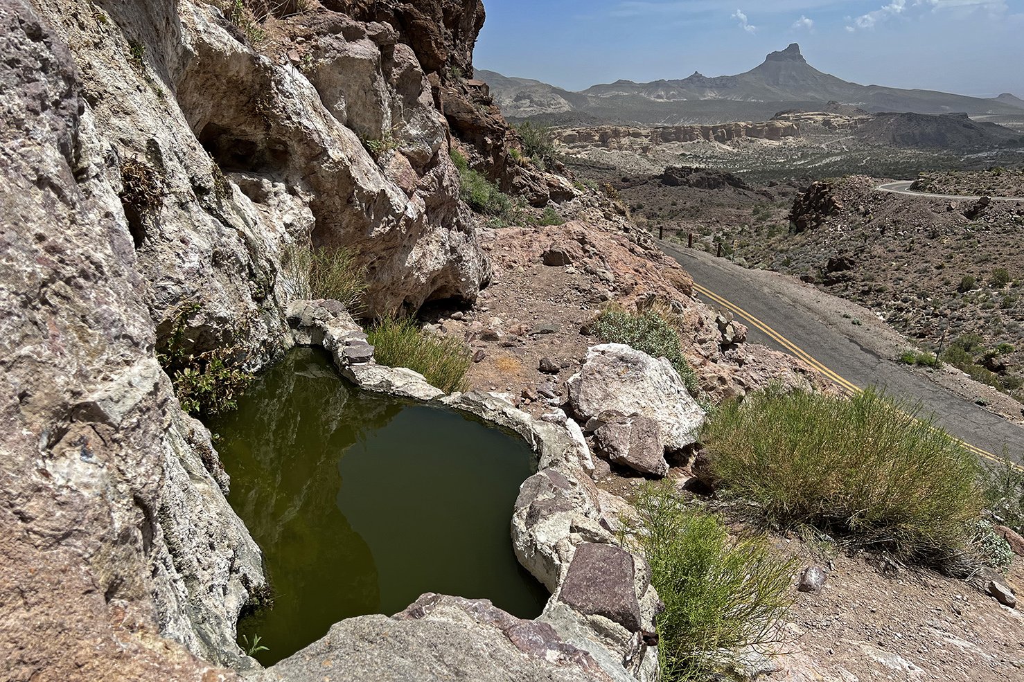
There were plenty of bees enjoying the water seeping out of the nearby rocks, along with several other tiny pools in small cavities in the cliff face. I think the algae is winning.


An impressive opening in this giant rock face. Image on left is from 2014, image on right is from 2022. Dontcha just love crapitti?

It’s always exciting to run across one of these old stone cabin ruins. This one was right near the road and is fairly decent sized. Looks like it was originally two rooms, with a door on each end of the building and one in between the two rooms. Was it a miner’s cabin? An office? A storeroom? That’s part of the fun in finding such places. Guessing what it was used for. Sometimes, it’s pretty easy to figure out. This one? No idea, so I’m going with cabin/dwelling.
I’m sure there’s more to see, so a return trip is needed. There’s a picture on the web of a small cemetery up above the Gold Road Mine complex. Hopefully, it’s not on private property, as that would be interesting to visit in person.
Return to Arizona Home Page
Follow on Instagram @exploratographer


-
 GoPro or Go Home - Joshua Tree National Park https://t.co/TJAShuigdc
 -
The Barbed Wire Trail - Joshua Tree National Park https://t.co/o0FKwmB68R